The ecological transition generates a technical paradox that is well known to those on the ground: data exist, in increasing quantities, but they often have no effect on decision-making. Sensors continuously measure water quality. Meters report energy consumption in real time. IoT networks collect rainfall, piezometric levels, and concentrations of atmospheric pollutants. And yet, decision-makers, whether water network operators, land managers, industrial operators, or engineering firms, still frequently work from fragmented dashboards, manual exports, and application integrations that are costly to maintain.
This observation is not a criticism of measurement or collection solutions: these technologies are mature. The problem is elsewhere: it is architectural.
A fragmented data landscape
Environmental monitoring systems (water quality, energy efficiency, air quality, waste management, natural hazards, biodiversity, etc.) have been developed in a sectoral manner. Each business domain has its own formats, protocols and interfaces. An operator who wishes to cross water quality measurements with precipitation data and regulatory alerts for exceeding thresholds must typically manage three or four separate systems, without a standardized gateway between them.
This fragmentation has concrete consequences. The correlation between an air pollution episode and industrial traffic data requires weeks of manual processing. The detection of an anomaly on a water network requires reconciling files from remote reading systems, GIS mapping and weather data, often in incompatible formats. Optimizing a building’s energy consumption requires aggregating flows of electrical, thermal, and hydraulic meters, each in its own application silo.
As environmental reporting obligations become stronger (CSRD directive, water and air regulations, PCAET, etc.) and as territories engage in energy sobriety initiatives, the absence of a standard integration layer becomes a real operational obstacle, and no longer just a technical subject.
The real issue: semantic data interoperability
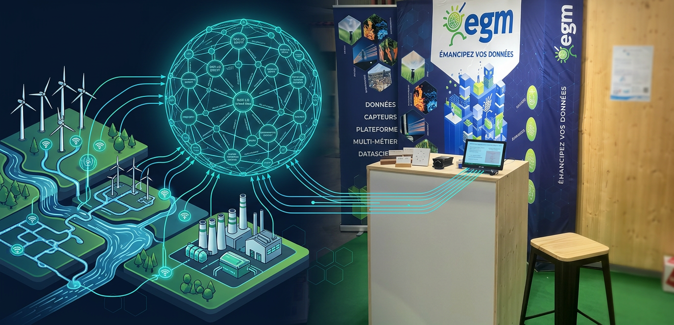
The answer to this fragmentation is not to adopt a single centralized platform that would replace all existing systems. This approach has shown its limits in terms of cost, resistance to change, and especially dependence on a supplier. The real lever is semantic interoperability: the ability to make heterogeneous systems talk together by imposing on them a common data model, based on open standards.
NGSI-LD, a specification standardised by ETSI and adopted as the European standard, meets this need. It models data in the form of a knowledge graph, with formal semantics based on JSON-LD. A pH measurement from a field sensor, a power consumption from a connected meter, a biodiversity indicator from a GIS base, all can be expressed in this common model, with their semantic context, geographical location and temporal dimension. Once aligned with this standard, independently designed systems can query each other, subscribe to each other, and power cross-functional applications without rewriting.
This is exactly the lock that EGM platforms are working to lift.
What the EGM platforms bring
EGM has been developing since 2010 a technical offer built on the principle that data has value only in the decision it allows to be made. This conviction is reflected in an open, interoperable and sovereign platform, structured around several complementary building blocks.
Stellio: the NGSI-LD data core
Stellio is EGM’s open-source data core, compliant with the NGSI-LD specification. It is the heart of the integration layer: it aggregates heterogeneous data flows, normalizes them into a common semantic model, and exposes a unique software interface (API) to publish, request or subscribe to them in real time.
Among its operational capabilities directly relevant to environmental projects:
- Native time series management: measurement data is stored with its history, searchable over arbitrary time windows
- Geographic Properties: Each entity can be localized, and subscriptions can be triggered when a value exceeds a threshold within a given geographic scope—useful for water quality alerts or exceeding atmospheric standards
- Federated deployment: several Stellio instances can operate in federation, which allows separate territories or organizations to share data without imposing centralization
- FIWARE integration: Stellio integrates into the European open-source FIWARE ecosystem, ensuring sustainability and independence from a proprietary publisher
Stellio is released under the APL 2.0 license. This means that a water syndicate, a natural park or an agglomeration can deploy, modify and mutualize the solution without commercial constraint.
Twin·Picks : the orchestrator of digital twins
Twin·Picks is the platform’s management interface, built on the model of digital twins. The idea is to dissociate the digital representation of a physical system (a catchment area, a district heating network, an industrial zone) from its underlying data sources. This allows you to change the sensor, add an operator, or modify a processing algorithm without rebuilding the business application.
Twin·Picks natively orchestrates Apache NiFi for data flows, Grafana for operational visualization, Apache Superset for BI analysis, Keycloak for access rights management, and connects to networks such as LoRaWAN. The whole constitutes an integrated environment, where each brick can be replaced or extended independently.
Applied to water management, EGM has implemented this approach on concrete projects allowing to describe, analyze, predict and prescribe on real water systems. Digital twins feed operational alerts and decision support tools, not just dashboards. The MARCLAIMED project (2024–2027) is industrializing this approach at several pilot sites.
LoRaWAN and edgeSpot: the ground layer
The collection of environmental data often takes place in contexts that are difficult to access mobile networks: wetlands, industrial sites, rural watersheds, coastlines. The LoRaWAN protocol (range up to 15 km in an open area, energy consumption compatible with a battery life of several years) has become the reference for these deployments. edgeSpot, EGM’s hardware platform, accelerates field deployment thanks to a modular architecture (more than 1,000 configurations available), an industrial IP67 packaging, and the possibility of solar power. It supports LoRaWAN, Wi-Fi and cellular, which makes it adaptable to the constraints of each site.
Apache NiFi: heterogeneous data flows
Apache NiFi acts as a universal connector between the sources (IoT sensors, CSV files, OpenData APIs, business IS) and Stellio. Its ability to transform, filter, enrich and route flows on the fly is essential in multi-stakeholder projects, where source formats are systematically heterogeneous.
The question of data sovereignty
An environmental digital project involves a territory over ten to fifteen years. The issue of technological dependence is therefore not incidental. An infrastructure built on proprietary interfaces creates a lock: changing providers means rewriting integrations, exporting data in incompatible formats, and starting over.
The EGM approach is explicitly based on NGSI-LD (ETSI standard), FIWARE (European open-source community), and open licenses. These choices allow an operator to
replace any building block in the environment, pool developments with other territories, and integrate third-party solutions that comply with the standard.
For local authorities, water unions, or infrastructure operators, this architectural independence is a condition of long-term viability—not a marketing argument.
ENVIROpro Martigues : a concrete area for discussion
These issues were at the heart of discussions during the ENVIROpro Sud-Est exhibition, on April 1 and 2, 2026 in Martigues, where EGM was present. Each year, the exhibition brings together environmental and energy professionals from the South-East region (local authorities, manufacturers, engineering offices, network operators). The discussions held on site confirmed that the issue of data integration is no longer perceived as an IT topic: it has become an operational challenge for field teams and technical departments.
The question is no longer “should we digitize?” but “how to connect what already exists?” It is precisely to this question that Stellio, Twin·Picks, edgeSpot and NiFi provide concrete and deployable answers.
EGM, created in 2010, is a specialist in the implementation of interoperable IoT systems based on open standards. Stellio, its context broker NGSI-LD, is available as an open-source (APL 2.0). EGM has more than 34 applied research projects in the fields of water, energy, smart territories and agriculture.
→ Our water offers